|
|
Club Expedition to
Alaska 2010 |
|
|
News items or reports on club activities
should be sent to website@liverpoolcanoeclub.co.uk |
||

Club
Expedition to Alaska 2010 (Crossing Prince William Sound form West to East) –
“Awesome”

Ever since the clubs first expedition to Alaska in 2008 a group of us had been
planning to return in order to cross from Whittier to Valdez using sea kayaks
hired from Tom Pogsons Alaskan Kayak School based in Homer. 8 of us completed the journey returning on
the Alaskan State Ferry to
Brian Green, Theo Gaussen,
Frankie Annan, Ian Bell, Mike Alter, Chris Franks, Kirk Williams and Keith
Steer
The Flight out - getting to Whittier
We had all booked flights at various times and prices so the plan was to meet
up in Seattle for the connecting flight into Anchorage. As the Alaskan Airlines flight made its final
approach the strong gusty winds and waterlogged Arctic tundra below hinted at
the reported 40 days of rain and poor summer so far. It was one of the bumpiest landings I had
ever encountered. 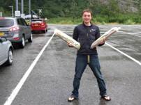
We soon all met up in the terminal and headed for the hire cars and headed off
to our Motel 6 accommodation for the night.
Some of the team decided to head out later that night to find a bite to
eat (about 1am) and did not tell the others!
In the morning we enjoyed our complimentary cup of
coffee and headed off to seek provisions at Fred Meyers (famous Alaskan
Supermarket). While some of us took our
dietary requirements seriously (Cheesy Broccoli and pasta X 12 days supply) others were more concerned with checking out
the pink riffle and ammo and latest camping gadgets for sale in the non-food
section of the store.
After an eggs based
breakfast (fast food), more coffee and the purchase of lunch (2 x 2ft
sandwiches) we headed for our final stop, an REI outdoor store to check out more
outdoor gear. The two hire cars were now
packed to the brim and we headed out of town for the tunnel under
More
Photos – getting to Whittier…….
Day One
–
“Somebody pinch me, I’m in
That was the thought as I woke up in the hotel at
the beginning of a rather hectic first day after such a long flight. Eager to
get going, the four excited paddlers in my room had to wait for the party
animals from next door to poke their weary heads out of bed before we headed
off to a supermarket to get breakfast and then begin the biggest supermarket
trolley dash you have ever seen to ensure that we all had enough food for the
two weeks away. This trolley dash was made all the harder by the fact that 1)
It was a new supermarket layout and we didn’t know where items where, 2) It was
full of brands that were unknown, 3) Being the organised lot that we are we
hadn’t set menus in advance (accept for Keith and Kirk who looked like they
were going to live on cheesy broccoli or cheesy potato!) 4) In my case they
didn’t have that most useful of things when it comes to shopping, someone to do
it for you! 
Fully stocked it was off to that most important of
places, the outfitters, to stock up on those last minute essential such as new
boots, a map and other various odds n sods. Alas, all too quickly we had to
leave the REI emporium and head to
The drive to
Just out of the harbour, we ran into a small group
heading back in being led by a rather gorgeous, in Theo’s eyes, kayak guide.
Awesome!
We are now on the shake down paddle, it’s a quick
few hours to the probable campsite and we can still go back if we have
forgotten anything. My seat is uncomfortable, but I am hoping that time at
first camp will sort it out and for now it’s time to sit back and settle into
the rhythm of the trip.
 Arriving at Squirrel point, this is the
first time camping in bear country for most of us, and we are a bit wary of how
to proceed. Just remember the guidance, talk quietly and stand firm if it’s a
black bear, play dead until it leaves you alone if it’s a brown bear. We land
and the first timers are surprised to see a rather nice cabin ($10k fine for
using without permission), composting toilet in its own hut and tent platforms
spread out amongst the forest – these, along with the connecting boardwalks
help minimise the human impact in the fragile environment.
Arriving at Squirrel point, this is the
first time camping in bear country for most of us, and we are a bit wary of how
to proceed. Just remember the guidance, talk quietly and stand firm if it’s a
black bear, play dead until it leaves you alone if it’s a brown bear. We land
and the first timers are surprised to see a rather nice cabin ($10k fine for
using without permission), composting toilet in its own hut and tent platforms
spread out amongst the forest – these, along with the connecting boardwalks
help minimise the human impact in the fragile environment.
A first meal under the tarp is soon followed by
sorting of foods, apart from for Keith and Kirk who have a very simple menu,
and then checking / fitting boats ahead of creating the bear cache. You are
supposed to hang food 5m above the ground, but with 12 days food for 8 people
this is hard, if not impossible. So we placed all foods in multiple zip-locked
bags and then dry bags to hide the scent, moved it away from the tents and hide
it under the tarp with pots and pans on top to scare away any bears (or at
least provide an alarm).
Off to bed with a hunger to get under way in the
morning – I must admit to being kept awake by any unexplained noise in the
night.
Mike Alter. More
Photos of day 1…….
Day Two
– Squirrel Point to Culross Passage
Waking up in the tent platform in the woods, thankful to have survived the
night with no bear encounters (it was me thrashing around in the bushes  after falling off the boardwalk!). I have to
admit to some feelings of trepidation, at the beginning of our first full day.
Challenge number 1 – get breakfast eaten and the boat packed and not be the
last on the water! Then as we are about to launch, Keith warns us of the wind
forecast and more nerves kick in.
after falling off the boardwalk!). I have to
admit to some feelings of trepidation, at the beginning of our first full day.
Challenge number 1 – get breakfast eaten and the boat packed and not be the
last on the water! Then as we are about to launch, Keith warns us of the wind
forecast and more nerves kick in.
So we head
away from Squirrel Point into some swell and wind to begin the journey to see
Blackstone Glacier. As we pass Decision point I see my first Alaskan Glacier –
wow! I suddenly stop thinking about the
uncomfortable back rest, wind and waves and start to feel excited. Then the
wind really picks up and the paddle into Blackstone becomes a battle. After what feels like forever, slogging into
wind and waves, a retreat is called. (The thought, is this a holiday? did cross
my mind) We return with a following wind (much easier journey) to a sunny beach
in a sheltered position for elevenses, then a sunny lunch watching the white
caps gradually disappear.
As the wind dropped we headed off again, paddling
for the point we could see ahead of us.
The wind was less now but still enough to test our boat handling. A quick stop at Surprise
cove before setting out again to get around in Culross Passage and our campsite
for the night. I could now relax
into my comfort zone, chopping and cooking.
Frankie Annan. More
Photos of day 2…….
Day
Three – Culross Passage to
With less wind that the previous day and a good forecast we set of from our
campsite at a  headland called Peter, close to north end of
Culross passage. Once clear of the bay we headed straight out
for our first and longest open crossing of the trip so far. We Headed for
Esther point, which was the south west point of
headland called Peter, close to north end of
Culross passage. Once clear of the bay we headed straight out
for our first and longest open crossing of the trip so far. We Headed for
Esther point, which was the south west point of 
Once across we spent most of the rest of the day
paddling along the south of  we started our crossing of the wider south
end of the passage we saw a boat that was known to those who were on the 2008
trip. The “Klondike Express” which does daily trips from
we started our crossing of the wider south
end of the passage we saw a boat that was known to those who were on the 2008
trip. The “Klondike Express” which does daily trips from
Ian Bell. More
Photos of day 3…….
Day
Four –
 Leaving a very nice campsite at East Flank,
we continued around the coast – some of us had paddled the first half already
the night before in fact, but it was worth doing twice…. Crossing between a few of the islands, our
first (and last) whale was spotted (a humpback whale that rolled over and dived
away into the distance. My trusty Spork (fork, knife and spoon in one) which had remained
balanced on my day hatch for most of the day, was lost
to the deep as I attempted to put it away.
Having three pieces of cutlery in one isn’t an advantage when you lose
all of them at once.
Leaving a very nice campsite at East Flank,
we continued around the coast – some of us had paddled the first half already
the night before in fact, but it was worth doing twice…. Crossing between a few of the islands, our
first (and last) whale was spotted (a humpback whale that rolled over and dived
away into the distance. My trusty Spork (fork, knife and spoon in one) which had remained
balanced on my day hatch for most of the day, was lost
to the deep as I attempted to put it away.
Having three pieces of cutlery in one isn’t an advantage when you lose
all of them at once.
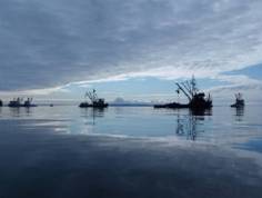
 We followed round the island past large
numbers of fishing boats using large, flat nets attached to the shore to trap
fish in the tide, and searched for the ideal campsite, eventually finding a
good beach on one of the small islands.
It was an island at high water anyway, separated by a tidal rapid of
sorts, which proved to be rather shallow.
I didn’t run aground on it however – I merely stopped in the middle to
see just how shallow it was, whilst paddling upstream….. Another day of warm sunshine, which started
off misty, and perfect flat calm conditions once again.
We followed round the island past large
numbers of fishing boats using large, flat nets attached to the shore to trap
fish in the tide, and searched for the ideal campsite, eventually finding a
good beach on one of the small islands.
It was an island at high water anyway, separated by a tidal rapid of
sorts, which proved to be rather shallow.
I didn’t run aground on it however – I merely stopped in the middle to
see just how shallow it was, whilst paddling upstream….. Another day of warm sunshine, which started
off misty, and perfect flat calm conditions once again.
Day
Five –
 The Day started windy and grey
as we crossed over to
The Day started windy and grey
as we crossed over to  boats hitting them on the hull
and popping up right next to us. Coming round the corner we were greeted by
some puffins hiding in some caves before finding a whole beach full of Stella sea
Lions. Keith got too close and soon found himself with a wall of barking Sea
Lions in front of him and had to make a hasty retreat!
boats hitting them on the hull
and popping up right next to us. Coming round the corner we were greeted by
some puffins hiding in some caves before finding a whole beach full of Stella sea
Lions. Keith got too close and soon found himself with a wall of barking Sea
Lions in front of him and had to make a hasty retreat!
After investigating a blow hole we then
saw our first Iceberg which had come of
Theo Gaussen. More
Photos of day 5…….
Day Six
– Flent Point to Columbia glacier Terminal Moraine
 After a night of rumblings and large cracks
as the ice flows outside our tents moved with the currents and lumps of ice the
size of houses cracked and split under their own weight at the tide left them
high and dry on the beach we packed up putting all our spare clothes on to
paddle through the ice towards the Columbia glacier terminal moraine.
After a night of rumblings and large cracks
as the ice flows outside our tents moved with the currents and lumps of ice the
size of houses cracked and split under their own weight at the tide left them
high and dry on the beach we packed up putting all our spare clothes on to
paddle through the ice towards the Columbia glacier terminal moraine.
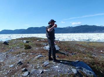
As we followed the left hand shore towards the
glacier the ice became thicker and we wondered if we would get through. After an hour or so we found a small cover
with running water and decided to pull in for elevenses (it was only 10.00am!) and
fill up with water as this may be in short supply on the gravels of the  moraine.
As we neared the old moraine ridge the ice became a solid wall, it was
clear we were going no further. All of
the ice carved from the 2km wide glacier had backed up against the moraine
ridge and only on high tide did some of the blocks have sufficient depth to
flow over the ridge which formed the lagoon and on out to sea. We decided to explore the surreal landscape
and head up over the massive mounds of debris to try and catch a glimpse of the
mighty
moraine.
As we neared the old moraine ridge the ice became a solid wall, it was
clear we were going no further. All of
the ice carved from the 2km wide glacier had backed up against the moraine
ridge and only on high tide did some of the blocks have sufficient depth to
flow over the ridge which formed the lagoon and on out to sea. We decided to explore the surreal landscape
and head up over the massive mounds of debris to try and catch a glimpse of the
mighty
From a
We were a little worried as the area was frequented
by bears and our stash of food (triple sealed in air tight bags) might prove of
interest to them in the night. In the
end we were not troubled and slept well on the very flat campsite.
Brian Green. More
Photos of day 6…….
Day
Seven – Columbia glacier Terminal Moraine to Long Point (via Long Bay and Schrader
Island)
 After
a cold night (the enormous Columbia glacier creates a strong katabatic wind –
the heavier, colder air rolls down the length of the glacier) we woke to a
glorious morning (strong sun and mist over the water) to paddle out among the
ice flows heading round the corner to Long Bay.
We paddled past some grounded pieces of ice. These towered over us and creaked and
strained under their own weight.
After
a cold night (the enormous Columbia glacier creates a strong katabatic wind –
the heavier, colder air rolls down the length of the glacier) we woke to a
glorious morning (strong sun and mist over the water) to paddle out among the
ice flows heading round the corner to Long Bay.
We paddled past some grounded pieces of ice. These towered over us and creaked and
strained under their own weight.
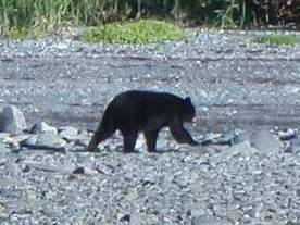
In long bay we passed several sea otters and headed
across a small bay  to find water. As we closed on a small stream we saw our
first black bear. As we landed he scampered
off into the under growth. As we filled
our water bottles we found numerous signs of his alfresco dinning, piles of
bear poo, discarded salmon heads and bones and the flattened vegetation
surrounding the stream. We had elevenses
(now a daily highlight) and chatted about the mornings paddle. However, we kept at least one eye nervously on
the shrubs behind in case our friend returned.
to find water. As we closed on a small stream we saw our
first black bear. As we landed he scampered
off into the under growth. As we filled
our water bottles we found numerous signs of his alfresco dinning, piles of
bear poo, discarded salmon heads and bones and the flattened vegetation
surrounding the stream. We had elevenses
(now a daily highlight) and chatted about the mornings paddle. However, we kept at least one eye nervously on
the shrubs behind in case our friend returned.
We explored the rest of the bay, creeping up on
every stream mouth, in the hope of seeing more bears but were unsuccessful. We landed on
Keith Steer. More
Photos…….
Day
Eight –Long Point to Elf Point
 This turned out to be a very
interesting day. Upon rounding Long
point we headed over to where a stream flowed over the beach to fill up with
water for the day. Two black bears were
wandering around the river delta, fishing for salmon. We watched for a while
before they wandered into the undergrowth at the back of the beach. We landed our kayaks and started to fill our
This turned out to be a very
interesting day. Upon rounding Long
point we headed over to where a stream flowed over the beach to fill up with
water for the day. Two black bears were
wandering around the river delta, fishing for salmon. We watched for a while
before they wandered into the undergrowth at the back of the beach. We landed our kayaks and started to fill our  water bottles. One of the bears then began to wander towards
us following the stream picking up several salmon on the way. This was our first on land encounter and we
nervously held our ground. The bear came
to within 50m before lumbering off behind some isolated ice blocks
water bottles. One of the bears then began to wander towards
us following the stream picking up several salmon on the way. This was our first on land encounter and we
nervously held our ground. The bear came
to within 50m before lumbering off behind some isolated ice blocks
We headed back past our campsite at Flent Point and paddled out into the bay to cross the ice
flows which seem thicker that normal.
After a mile or so the ice became thicker and thicker and we needed to
follow each other single file. Near the middle we wondered if we were ever going
to get through, the Bergy bits had to be prised apart
by the lead kayak and currents and wind could have meant that we would become
trapped in the moving sea of ice. After
several nervous moments Ian thought he could see a way through to more open water. Before long the ice thinned and we could
paddle to Elf point, our intended campsite for the evening. This was a steep stony beach with a floor of
pine needles under trees at the top of the beach; this would make for a more
comfortable night than the usual bed of pebbles. Kirk Williams.
 Seeing as the day had been so good so far,
the crossing of the ice was fantastic, and we weren’t all in the mood for
sunbathing, three paddlers ensured they had a spare tent and food to last the
day, and then headed off back to
Seeing as the day had been so good so far,
the crossing of the ice was fantastic, and we weren’t all in the mood for
sunbathing, three paddlers ensured they had a spare tent and food to last the
day, and then headed off back to
Reaching the edge of the ice, even though 8 miles
from the glacier on a moraine dam that is 5 miles wide, the glacial melt could
be seen acting as a river and we had to use river skills such as ferry gliding
from behind grounded ice berg to grounded ice berg to make our way in, where we
met with an amazing view of the sea of ice behind the dam and a group of
tourists who had been power boated out from Valdez for a couple of hours sea
kayaking and lunch at the margin of water and ice. The guide said our trip
sounded “Awesome”, but I’m not sure if that short paddle and lunch was worth
$230 each – ouch!
A quick brew stop, Hershey chocolate tastes of
vomit, and its back to meet the others and catch up on the last of the suns
rays.
Mike Alter. More
Photos of Day 8…….
Day
Nine – Elf Point to Sawmill Bay
“Get In!!!!!!”
Was the shout from Keith to Kirk, Brian and myself
as we paddled around the point. Although in the eddy behind the reef, we would
soon be head on into the full flow of the ebbing tide as it surged around one
of the crux points of the trip so it was sensible to follow the advice.
Careful planning had been necessary to ensure that
there was a good weather window as we rounded the point, as had been the case
at several other key points. The geography of Prince William Sound ensured that
the point was exposed to the full fury of any Pacific swells coming from the
south west, and there were no landings for 10miles as we began the entry into
Valdez Arm. Fortunately, the weather goods were kind and we breezed into the
sound, but all too soon we found ourselves battling into a head wind to make
our way towards  Sawmill bay, our camp for the night.
With  no landings for the first 10 miles, we were
headed for
no landings for the first 10 miles, we were
headed for
It was then off to
Mike Alter. More
Photos…….
Day Ten
– Sawmill Bay to
Another early morning escape from the midges, saw us stop briefly to top up the
water  supplies across from the campsite, before
heading off to cross a busy waterway, but as someone pointed out not quite as
busy as the
supplies across from the campsite, before
heading off to cross a busy waterway, but as someone pointed out not quite as
busy as the
After exploring some of 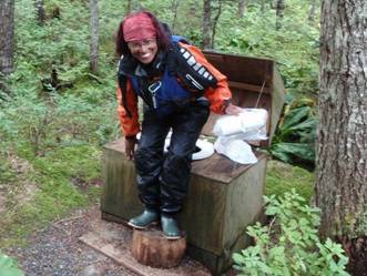 campsite, as the only person with a complete
tent that meant first choice of camping spot, as well as some modelling for
Keith. The most interesting latrine of the trip!
campsite, as the only person with a complete
tent that meant first choice of camping spot, as well as some modelling for
Keith. The most interesting latrine of the trip!
Frankie Annan. More
Photos…….
Wanting to paddle further and explore the bay,
those not heading to an early campsite surfed towards its upper reaches. There
we were met with a bed of reeds, but a channel of water heading further inland
kept calling us ever onwards.
Wary of being stranded by an ebbing tide, we headed
up through the swamp, ducking under trees and keeping an ever open eye for bear
sign. Alas we didn’t see any, and all too soon it was return or risk being
stranded. Reaching the bay it was a slog against the wind, lightened by a trip
under a waterfall – which ruined the sharks’ feather – and the exploration of a
tunnel. Then we had to find the campsite, hmmm, now which densely wooded part
of the bay had they decided to land on????????
Day
Eleven –
Leaving Jack bay, we stopped at a small waterfall to refill water bottles. This time we did not land, we used Brian, who
was sat in his boat filling the bottles from a small waterfall, as we passed
them to him. Once around the point we were in the  narrow but also a point where all the
tankers heading for
narrow but also a point where all the
tankers heading for
From Middle Rock we crossed to the west shore for
Elevenses and chose to land on a beach between two spectacular waterfalls. It
had started to rain at this point so we set up stoves and stood huddled
together under a rock overhang for shelter. As we had our drinks and snacks
Mike suddenly said there’s a Bear. With some disbelief we reached for our
cameras and all gazed across the stream trying to grab a glimpse of the bear.
We didn’t see anything until Mike pointed out to us that it had crossed stream
and was on the beach  heading
for us now only about ten yards away. As most of us tried to get photos
Keith jumped up to run to for his boat (his excuse was supposedly to get his
camera from his boat). With his movement the bear suddenly realised we were
there and doing a back flip quickly ran off back up the rock cliff next to the
waterfall.
heading
for us now only about ten yards away. As most of us tried to get photos
Keith jumped up to run to for his boat (his excuse was supposedly to get his
camera from his boat). With his movement the bear suddenly realised we were
there and doing a back flip quickly ran off back up the rock cliff next to the
waterfall.
Having left the waterfall we carried on northward towards
 bit of exploring from the bank returning just
as tide was about to lift our boats away. Having to wait a few hours for the tide we
paddle back to shelter by cabin and to have lunch.
bit of exploring from the bank returning just
as tide was about to lift our boats away. Having to wait a few hours for the tide we
paddle back to shelter by cabin and to have lunch.
After chatting to a group that had stayed the night
in the cabin we returned to run the channel into the lagoon on a rising
tide. We quickly identified a suitable
camping spot before spending the afternoon paddling across to Shoup Glacier taking those once in a lifetime type photos. We paddled back past
Ian Bell. More
Photos…….
Day
Twelve –
The final day…..
The day dawned as grey and murky as the two before
it - earlier than usual, as we had to catch enough water in the channel out of
the Shoup Glacier lagoon to avoid hitting the bottom. Luckily, the reconnaissance mission the night
before by Ian, Mike and I had paid off, and we all escaped into the open sea
without problem. Fog banks had descended
on the valley overnight, and although visibility was a bit limited, we set out,
hugging the north bank of Port Valdez.
Brian continued to hug it, even when the rest of the group was about
half a mile out, but the scenery at close quarters was fabulous, so we let him
off. More murkiness followed, broken up
by an old mine working which we paused to examine. We stopped in the pouring rain to ensure that
our food 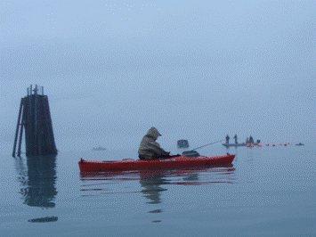 calculations had been correct to the nearest
crumb, and that we should arrive back in
calculations had been correct to the nearest
crumb, and that we should arrive back in
Continuing, we encountered a fishing competition
just outside Valdez – the sheer number of boats was unbelievable, as was the
number of jumping salmon - some even jumping over the kayaks as we paddled
along. Landing on a beach in  were so many err… ‘heavy
boned’ people around
were so many err… ‘heavy
boned’ people around
Wet gear was draped over every possible immovable
object in the hotel rooms. Even the
curtains were replaced by Terra Nova footprints, and water dripped
everywhere. After a good meal, a few
ventured out into the local bars, having been assured by the ferryman that we
could be sure of a fight in one particular location. We investigated the matter, and sure enough,
a nice local chap who resembled Mark ‘Chopper’ Read in the film, but with no
hair, obliged after about two minutes.
He said he’d like to rip Brian’s head off, but the live music was good,
so we decided to stay. Anyway,
proceedings went on into the morning, and we managed a couple of hours kip before getting up at 5 the next morning….
Chris Franks. More
Photos…….
The Trip Home (via 
The long journey home began with an early start. Our hotel room decided to get up at 5am to
beat the others in staggering the boats the half mile to the Ferry terminal (we
had been out the night before till 4am). With Keith having left his passport in
the hire car in
With us all back in
 Theo G. More
Photos…….
Theo G. More
Photos…….
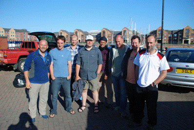
We hope to return in 2012 to explore
Brian Green,
Theo Gaussen, Chris Franks, Mike Alter, Frankie Annan, Keith Steer, Kirk Williams and Ian Bell
For some more video from
http://www.youtube.com/user/paddlermike