|
|
The |
|
|
News items or reports on club activities should be sent to website@liverpoolcanoeclub.co.uk |
||

The
The River Tay is the longest river in
 The
The
Day 1
– Tuesday Crianlarich to
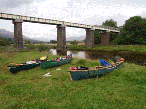
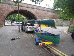
Ian and Simon met at my house and we loaded our three opens
on a small trailer and headed up the M6 to
Arriving at Crianlarich we soon found the get in down a small track immediately before the railway bridge. After a little persuading, Ian drove the car and trailer down the track to the rivers edge. Gear and boats were unloaded very quickly; it is very easy to load two dry bags into an open boat and tie them in. While Ian parked the car in the police station car park we were approached by a local character. He and his dog apparently earned their living by panning for gold in the streams around Crainlarich. Apparently small deposits can be found in every river valley around Tyndrum. There’s GOLD in them thar hills! After discussing our plans we were off, hoping to get to one of the Lochs to camp before nightfall.
 After a few miles of gentle
flowing stream we passed the castle on Loch Dochart and entered Loch Lubhair
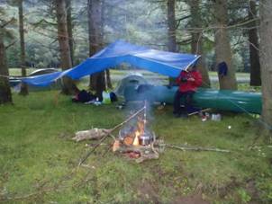
where we found a campsite on a small semi-island at the south end of the
lake. We soon had the tents and
tarp up and Simon set about lighting a fire. With a few notes of guidance from Simon,
wild mushrooms were added to the evening meal of Thai green curry and
rice. Ian and Keith both had tents
but Simon was to bivi out under a tarpaulin. The midges, although present were not
too bad, especially given that it was late August – no doubt kept at bay
by the rain and smoke from the fire. Simon
“Well as long as you’re appy!!
After a few miles of gentle
flowing stream we passed the castle on Loch Dochart and entered Loch Lubhair
where we found a campsite on a small semi-island at the south end of the
lake. We soon had the tents and
tarp up and Simon set about lighting a fire. With a few notes of guidance from Simon,
wild mushrooms were added to the evening meal of Thai green curry and
rice. Ian and Keith both had tents
but Simon was to bivi out under a tarpaulin. The midges, although present were not
too bad, especially given that it was late August – no doubt kept at bay
by the rain and smoke from the fire. Simon
“Well as long as you’re appy!!
Day 2
– Wednesday Loch Lubhair to the Southern end of Loch Tay
It rained constantly over night and in the morning the river
was noticeably higher. This was good
news as it would help us swiftly on our way. After smaller rapids and a few bridges
we came across the first major drop, Corriechaoroch rapids. This was a technical grade 3 with two
rocks in the middle that could easily broach an open canoe. Having survived this rapid we enjoyed
the grade 2`s below with 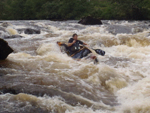 shoot after shoot and
a few drops thrown in for fun (Lix
rapids). Simon “Well as long as you’re appy!! As the valley deepened and became
more wooded we had to negotiate a rope across the river at neck height near
some building work.
shoot after shoot and
a few drops thrown in for fun (Lix
rapids). Simon “Well as long as you’re appy!! As the valley deepened and became
more wooded we had to negotiate a rope across the river at neck height near
some building work.
We got out at Kilin just above the “Falls of Dochart”. There is a war memorial just before a steep wall on river right which depicts the run in to the rapids. These are about 200m long and would provide good fun for kayaks. We did not want to risk damage to our boats (another group had pinned their open midstream while lining down under the bridge) so we portaged around the main falls to the bridge. Simon “Well as long as you’re appy!! During the portage a guy started chatting to us and said “I thought it was 3 men in a boat but you `re 3 men and 3 boats!”
Not wanting to carry down the main street and make the
portage nearly one kilometre long we put in just under the bridge via some
rough land on the river left. After
a short lunch we paddled, lined and walked our canoes down the 200m of rapids
below the bridge. One drop had a
noticeable stopper and strong tow back so we all lined down a small ramp on the
 left.
left.
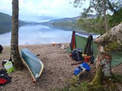
At the old railway bridge the river flows more sedately into
Loch Tay. By now it was about
2:30pm. We paddled in perfect
conditions down to a small rocky island on the left bank and took a second,
late lunch break (very late as it was now around 4:00pm). Suitably refreshed with tea and coffee
we paddled on towards to bottom of the
Within sight of the bridge at the end of the 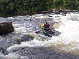 stream running just
behind the campsite. Simon
soon had a fire going on the isolated beach, evening meal on and tents up and
fantastic view down the remainder of the
stream running just
behind the campsite. Simon
soon had a fire going on the isolated beach, evening meal on and tents up and
fantastic view down the remainder of the
Day 3
– Thursday Loch
It took less than an hour to paddle across to the bridge and onto the River Tay itself. A grand hotel overlooks the river here and there is a large caravan park on the left bank. The river is relatively swift and numerous rapids kept our interest on the way down to Aberfeldy. There was nothing more than grade 2 (Chinese bridge rapids (Grade 2) but a very enjoyable section of river. We had lunch on a small shingle bank just below Aberfeldy bridge.
The river began to flatten out after Aberfeldy but still had
numerous rapids and good scenery.
It was not long before we came across a group of students and kayak
instructors having lunch at the top of the white water section of the
A quick inspection and decision on route choice at the top
and we were off. Simon drifted a
little close to a large tree on the top slot but survived the scare and paddled
down to break out neatly in an eddie marked by an upstream gate. We bailed and 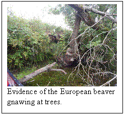 sponged out any water taken on board and
headed down through the bridge to the large natural weir below. We shot this on river right through a
reasonably sized stopper and again sponged out in the eddie below.
sponged out any water taken on board and
headed down through the bridge to the large natural weir below. We shot this on river right through a
reasonably sized stopper and again sponged out in the eddie below.
 From here on down it was grade 1-2 with
more and more fishermen learning the dark art of fly fishing. After a few miles we came across
evidence of beaver activity, gnawing at trees to fell them, bark being stripped
for food etc. Our wilderness guide
Simon informed us that they were no ordinary beaver but a European variety that
had been reintroduced to areas of
From here on down it was grade 1-2 with
more and more fishermen learning the dark art of fly fishing. After a few miles we came across
evidence of beaver activity, gnawing at trees to fell them, bark being stripped
for food etc. Our wilderness guide
Simon informed us that they were no ordinary beaver but a European variety that
had been reintroduced to areas of
'")
After a few hours paddling we started to look for a campsite
for the night. At the confluence of
the River Tummel, Logierat, we spotted a good campsite under some trees behind
a small sandy beach. We had seen
several boats with “Ghillies” ferrying clients back from their days
fishing and assumed that most were winding up for the day; it was now
5:30pm. We erected the cooking
tarp, two tents and Simon’s tarp for sleeping under. We were then approached by a Ghillie,
Jim McEwen from the local estate.
“You  can’t camp here, its
private land”. He was so nice
about it and very quietly spoken that although we tried to argue the point it
was almost impossible. He rang his
boss to tell him that a group of canoeist had set up camp on his beat. He redirected us to a site past the next
railway bridge, a grey boat and by a deep fishing pool that was not used
currently. Although tired and
looking for a rest we started to pack up and make our way downstream. Simon
“Well as long as you’re appy!! After about 40 minutes we came
across the grey fishing boat and deep pool at Dowally and landed on a small
shingle beach. We camped between
some young silver birch trees on some long meadow grass (we flattened this
using a canoe).
can’t camp here, its
private land”. He was so nice
about it and very quietly spoken that although we tried to argue the point it
was almost impossible. He rang his
boss to tell him that a group of canoeist had set up camp on his beat. He redirected us to a site past the next
railway bridge, a grey boat and by a deep fishing pool that was not used
currently. Although tired and
looking for a rest we started to pack up and make our way downstream. Simon
“Well as long as you’re appy!! After about 40 minutes we came
across the grey fishing boat and deep pool at Dowally and landed on a small
shingle beach. We camped between
some young silver birch trees on some long meadow grass (we flattened this
using a canoe).
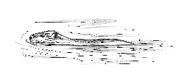
Although this site had no view and was very close to the A9 and had traffic noise late into the night, it was not too bad. After cooking our evening meal we started to pack up for a well earned night’s kip. Simon then spotted an otter eating a fish on the stone bank that we had landed on. We watched while he finished his meal before going back into the water and swimming away.
Day 4
– Friday Dowally (6km above Dunkeld) to
The next day we paddled down to Dunkeld in a little less
than an hour. The valley sides
started to close in and become wooded on both sides. This was a beautiful stretch of river
and had a very nice hotel and immaculate lawns on the left bank. We then paddled on round many meandering
bends to cover the 25km to  where the entire
river flows through a 10m wide gap between massive boulders. The fall itself is only a few feet high,
but the volume of water makes this a tricky place. Even in low water there are
large whirlpools below the main shoot. It is graded 3 but the main shoot in
very high water is generally accepted to be graded "scary". It was relatively low when we paddled
over – only the main shoot was paddleball.
where the entire
river flows through a 10m wide gap between massive boulders. The fall itself is only a few feet high,
but the volume of water makes this a tricky place. Even in low water there are
large whirlpools below the main shoot. It is graded 3 but the main shoot in
very high water is generally accepted to be graded "scary". It was relatively low when we paddled
over – only the main shoot was paddleball.
From above the fall, from left to right, the shoots are:
- The
main shoot. This always has enough water to run. In high water a tubing
wave forms here and the whole thing gets pretty dangerous. This is the
location of the largest inland whirlpools in
- Next to this (and merging with it in high water) is a rarely run shoot which goes under an undercut on the right that is visible in low water.
- Across the big lump of rock is the middle shoot which rarely run due to needing near flood conditions to be doable.
- Across the next lump is the standard high water line. A grippy hole can form at the bottom of this.
- Finally is the chicken shoot, often run by open canoeists as it won't swamp a boat and by scared kayakers paddling during a flood.
Below here we met two kayakers in red creek boats. We paddled over the main shoot on Stanley weir before they got on. Although this is also grade 3 in high water it was relatively easy with just a tail of moving water. The rapids below gave some more sport; some of the wave trains were quite large and some water sloshed over the gunwales (Thistlebrig Rapid grade 3). We stopped for an hour below the last main rapid to have a brew and relax a little in the last of the afternoon’s sun. Simon “Well as long as you’re appy!!
 We then paddled down
towards
We then paddled down
towards
Day 5
–
The plan was to leave at 8:00am so Ian got up at
6:30am!!! We were away by 7:15 and
paddled and drifted the short distance down to our egress point just before the
first
The Scottish City Link bus journey from
Ian returned at 1:12pm with the car and trailer and we loaded our gear and headed south. On the way home we compiled our list of most desirable (source to sea) canoe touring and expedition rivers. They are ranked in order of white water difficulty. How many will we be able to tick off in the next few years.
 1/ The Scottish Dee
2/ The River
3/ The River Wye
4/ The Welsh Dee
5/ The River
6/ The River Eden
7/ The River Spey
8/ The River Seven
9/ The Great
Glen (
10/ The River
Ian Bell, Simon (“Well
as long as you’re appy!!) Howlett and Keith Steer More
Photos………..