River Lune Beckfoot to Killington Sunday 8th January
 The heavy rain had eased overnight, and most rivers had returned to below-high levels. Game on and we returned to Burton Services to try to run the middle Lune again.
The Lune often runs when other rivers are too low so it’s often a fallback trip when other rivers are too rocky but it is also fun when it is medium-high. You can get an idea of the level from the EA gauge at Killington New Bridge, though since it is towards the end of the run, levels may have changed by the time you arrive. We’ve paddled it as low as 0.36m, which was fine in the gorges, but a bit scrapey on the first mile below Crook of Lune and one or two wider bits lower down. The river had been far too high the day before 1.49m but had dropped to 1.01m on the Sunday and looked at a good level.
The section we usually do is from Crook of Lune down to one of several take-outs near Sedbergh, most often Killington New Bridge (just above the weir that is gauged). You can get a link to current known hazards on the UKRGB guidebook page. It’s a river where some parts are wide and easy, others narrow and gorge-like, with one narrow strid. These narrower parts change character considerably at different water levels, some becoming easier as the river gets wider and deeper, whilst others get more challenging as the current builds sharp eddy lines and boils. At most levels, there’s nothing more than grade 3 if you portage the strid.
 Access: the river is paddled by some big groups, and the road down to Crook of Lune is very narrow with no parking space, so paddlers are asked not to take cars, and particularly not trailers, down to the river. Park by the B6257 road between the motorway bridge and the turn-off, or under the disused Lowgill viaduct just a short way down the lane (room for maybe three cars here, but turning is difficult). It’s a short downhill walk with boats (best done whilst drivers are shuttling), but does help keep good relations with the local community.
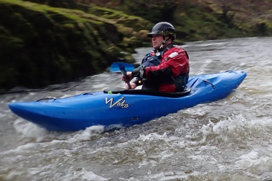
If it is low, the river here looks quite unpromising and can be quite a scrape at first. This lasts a mile or so with a few deep pools and the odd bouldery drop, before bedrock comes into view and the river channels down. There was no chance of hitting any bedrock today as the water was up to bankful and water flowing around some riverside trees.

The gorge is usually pool-drop and can cause upsets. With any reasonable level (low to medium) there is chance to regroup and fish out any debris after each drop. About two hundred metres in, a footbridge forms an obvious landmark. The bridge piers are concrete for about ten feet above the low-water level.

The gorge lasts for quite a way, often wider, with a few drops and plenty of waves. The gorge section ends abruptly, just above the “jumping bridge”, an old arched girder railway bridge popular for those who like to test their climbing ropes by jumping off one side with the rope tied to the other (underneath).
The river has another wide section of gentle gradient which can be slow at low levels. This ends with a narrowing, and the river accelerates towards a drop (Crowder’s Leaps), barely a hundred metres before the first potential take-out at Lincoln’s Inn Bridge. In high water, the rapids are bouncy, but the final drop is washed out and with plenty of room. At low water, boulders guard the entry line to a final steep drop into an aerated pool, leading immediately to a very narrow gap.

There’s a flat section after this, and under the bridge about a half mile of mostly easy rapids and flat pools. One good rapid eds on a right-hand bend, then the river flattens and widens, but with a rocky horizon line ahead. Get out river left to inspect the Strid, where the river funnels steeply down into a very narrow channel, unless the water is well up, when it forms a wider, but very turbulent drop, often the cause of widespread carnage. At low water, it may be too tight to run at all, particularly if there is any debris caught in it.
As it gets higher, this becomes less of a problem, and the drop at the end into a wide boily pool with sharp eddy lines is the cause of most grief. As everyone gets out to inspect this (unless you miss the last eddy…) it is one of the more photographed bits of river in our area.

The portage is river left, and most inspect this side, but there is a small eddy river right and a short walk and drop onto rocks is also good for inspection and photos.

After the strid is another gorge section, Killington gorge, which has had some nasty tree hazards at times, so keep a good look out ahead. In the absence of trees, this is an easier gorge, and with all the main difficulties behind, most groups will paddle on confidently.

Killington New Bridge is the most popular take-out, but you can continue beyond this. There are recent steps up from an eddy directly above the bridge, river left, but these are steep and missing the eddy would take you under the bridge. There’s a safer get-out about thirty metres upstream of the bridge, which has a bigger eddy, a good path mostly on bedrock (and not steep).
Sara B, Harry R, Ian B, Keith S, Martin A and Nikki A