Search
2025 05 28 Day 4 Les Vignes – La Cresse by Chris
2025 05 28 Day 4 Les Vignes – La Cresse (20km) grade 2(3-) for the first 10km to Le Rozier then grade 1-2(2+) by Chris
The plan was to paddle the section from Les Vines to La Rozier, a classic section that some consider the best on the Tarn, then follow on with the next section down to La Cresse. The second part was apparently less interesting, but none of us had paddled it before, so it’s always worth exploring. The instructions were to be ready to shuttle at 8 am, and ready to paddle immediately on returning from the shuttle.
The shuttle was straightforward – unusually, there were no switchbacks or minor roads, just following the same road all the way, except for one T junction. We realised that the traffic lights in the villages are speed-controlled – if you approach at more than the speed limit, they remain red, while if you follow the rules, they turn green shortly before you reach them. Much better than speed bumps. The bridge at La Cresse is single lane, and the original road on the West side has been widened so that vehicles can line up and check there’s nobody coming the other way. We put the cars on the original road so they were not in anyone’s way. There’s a narrow lane down to the river below the bridge, with a turning area leading into a campsite. It looks closed for the moment, although the gate was open and there were tempting suggestions that we could leave our cars there, but we decided they’re safer and less trouble to the locals where they are. Two anglers parked at the end of the lane and were making their way downstream. A quick look showed a gravel beach and a 50m carry.
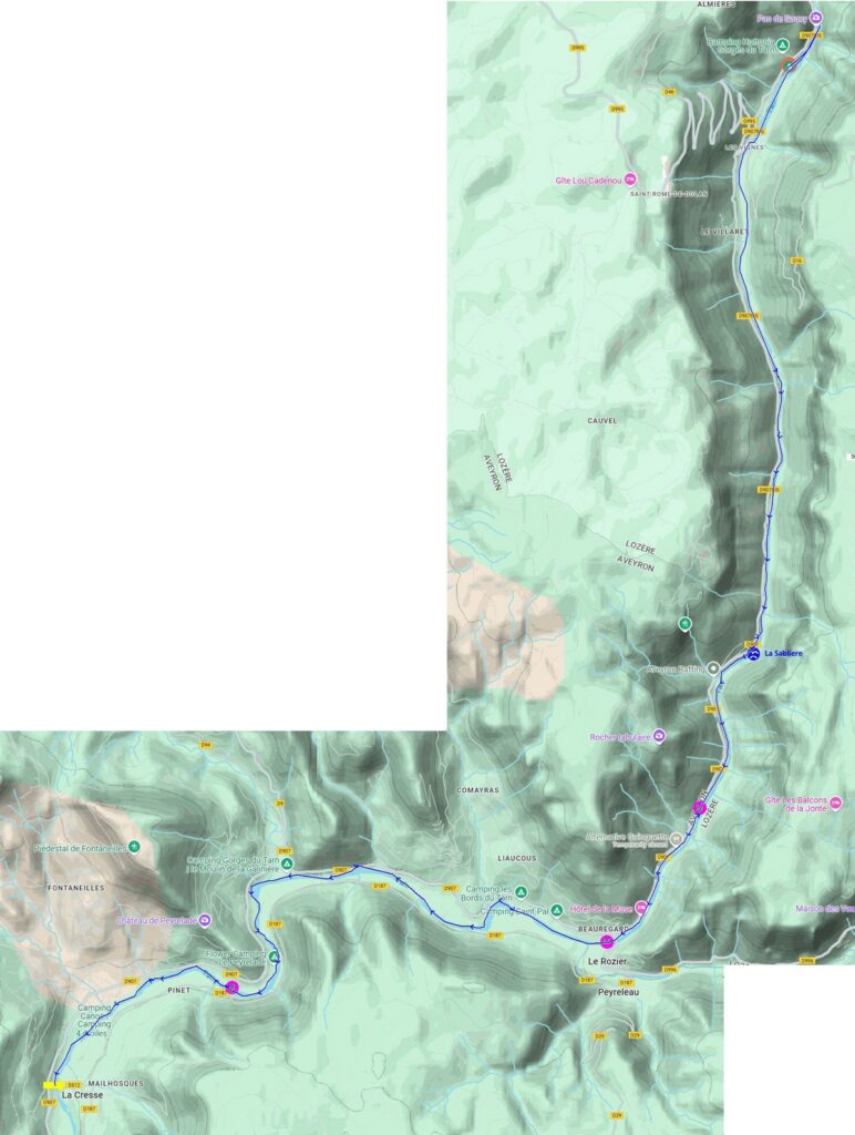
We went back to Colin’s car (which is actually Sue’s) and returned to our campsite, with a quick call at the shop in a village we passed through. For some reason, some of the villages have their name signs upside down, both entering and leaving! .
In rural France, many village name signs are being turned upside down as a form of protest by farmers. This action is a way for farmers to express their grievances about the challenges they face, such as rising costs, late subsidies, and bureaucratic hurdles. The upside-down signs are meant to symbolise the feeling that their world is being turned upside down due to these issues.
The shuttle drivers quickly got on the water for about 9 am. There didn’t seem to be much rush, although that may just have been because people were hiding in the shade (it was 20º already and forecast to rise to 30º), so we paddled up to the Pas de Souci and looked at the river flowing out from the boulder choke. The main flow was only 1.5m wide, but there was a weak current from under the boulders on river right, fed from a syphon, but safe to approach on the downstream side.
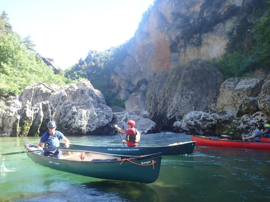
The group came together at about 9:30, and we paddled down to Les Vignes. While scouting for a restaurant the previous evening, the weir appeared (from the bridge downstream) to have two very steep-looking chutes. Some of the glissiéres have a fierce reputation, so when Nikki led us towards the chute on river left, it was clear that it wasn’t as steep as it looked from the bridge and several followed. In fact, it wasn’t a glissiére but fish steps, similar in proportion to those at Chester. Once down, we paddled along the bottom of the weir and reached the actual glissiére, which was much steeper. Several of the team paddled down it, some with arms in the air, and it did, as had been said, turn out to be much easier than it looked.
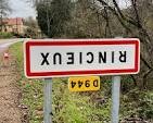
We carried on down, paddling through typical Tarn scenery, although a little more open than before, through grade 1 and 2 rapids to reach the grade 3- rapid of La Sabliere (which means “the sand pit” or “the sand quarry” but can also refer to an hourglass) at 11:15. This was preceded by a stern warning notice on the bank (aimed at the many hired SOT paddlers) insisting that buoyancy aids and helmets are essential. The rapid has slightly bigger boulders than others, but the flow starts off slow, and it’s not hard to pick a line. All the routes funnel down to a chute at the end, and there were no mishaps.

Continuing on, we stopped for brief elevenses at 11:45 and reached Le Rozier an hour later. The original bridge had fallen into the river many centuries ago, and there had been an attempt to build a new pier using the tilted one as a foundation. There’s a fairly modern bridge now. There were hopes that a cafe would be found for lunch, despite there being none open on the 2023 trip. Chris, Colin and Sue stayed with the boats as they were on a public beach. The cafe hunters found some chips, but that was all, and no restaurant possibilities for the evening.
The rest of this post has been hidden and is only visible to logged in members. Click here or tap the login tab on the main menu or enquire about membership.
Still can’t believe that only i saw the snake whilst we were walking the boats to the car at the get out.
Excellent river, excellent scenery, excellent company. 😊