Search
Open Canoes on the River Tweed 2024
Day 1 (Saturday) 25th May – Peebles to Newstead
The second May Bank holiday was fast approaching, and Nikki suggested a three-day trip down the river Tweed on the Scottish border. Club open canoes were available, but we ended up with 6 paddlers, all paddling their own craft: Nikki, Martin, Keith, Ian, Mike and Ruth. Most headed up on Friday evening/night and camped or bivvied in Peebles. The plan was to shuttle the cars to Berwick and Keith would pick up the drivers and take them back to Peebles on Saturday morning.

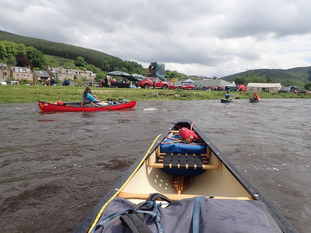
We put in at Peebles and were on the water by 10:30 am and paddling off at a great rate of knots with the river at a good level. From here the river is grade 1 save for Walkerburn Cauld, all the way to the grade 2 Fairnilee rapid at Yair Bridge. The car park here is free and has public toilets beside it.
We zoomed down past wooded valley sides and past Kailzie Gardens and house. Near Cardrona, the river sweeps into a sharp bend as it meets the A72. Some massive and expensive river defences have been built on the outside of the bend to stop it from eroding and undercutting the road. We were soon down to Innerleithen and happened across a sevens Rugby Tournament at Walkerburn Rugby Club. Well, it was now elevenses and it would have been rude not to try the venison burgers on sale as part of the fete.
After sitting in the sun and chatting to a few interested locals we headed on down the river padding Caddonlee and on to Fairnilee Rapids where we had spotted a low-level slalom competition on the shuttle up. Fairnilee is a two-part, grade 2 rapid, with the first part a shoot under the bridge and the second part a drop not long after. The competitors just waited until we had all paddled down through and got out of their way. Some of us even missed getting a time penalty by missing all the poles!

Further on down, we passed the impressive house of Abbotsford, the home of Sir Walter Scott.

We paddled through Tweedbank and all the houses and industry without even knowing and then on to Melrose. This was the first major weir (Melrose Cauld). This is a gnarly-looking weir with all sorts of angular boulders. We have lined down in the past but with higher levels, Martin managed to find a route through on the river left. The right-hand side had considerably more water going over it and was best avoided by open canoes.
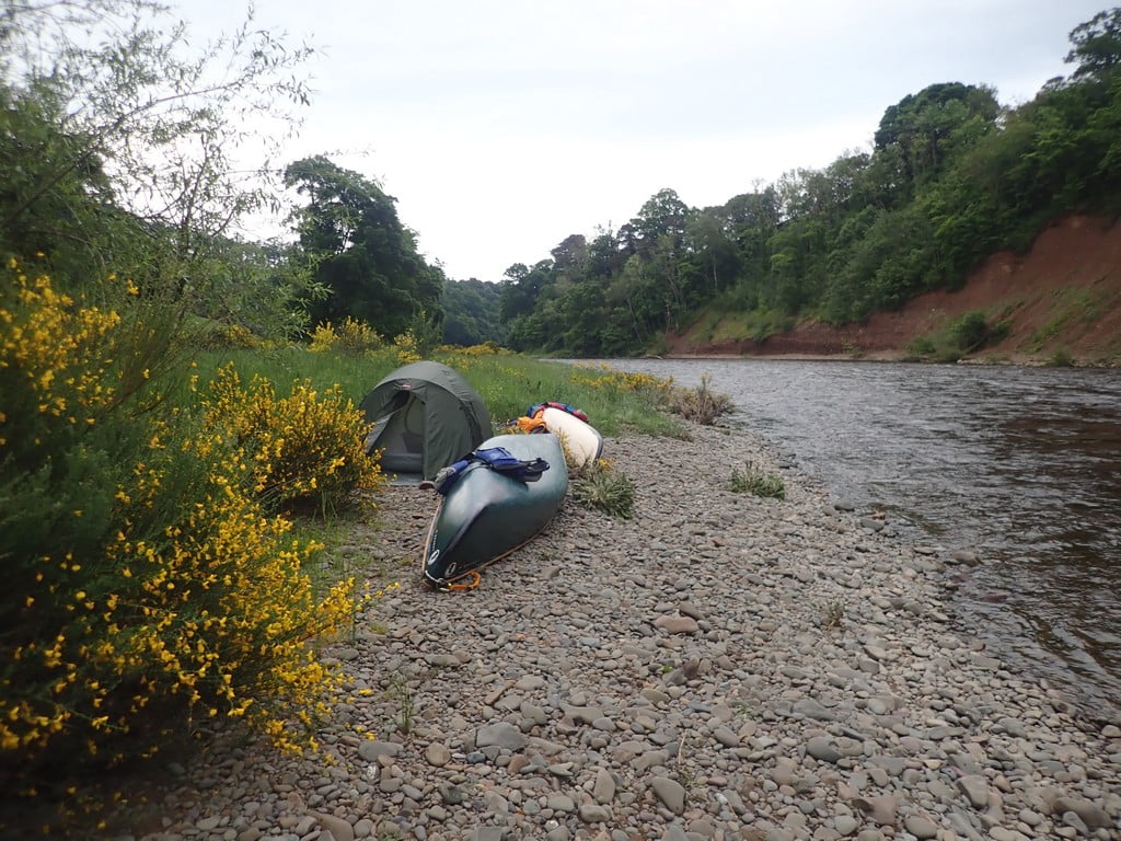
Here it was a relatively short paddle down to the large sweeping bend with the steep red-coloured cliff and cutting. The island was overgrown and the landowner had been trying to stabilise the ground by planting new trees. Half of the group set up camp in the long grass while others preferred the top of the stoney beach. It was at this time that I realised that I had left the outer waterproof part of my tent at home along with the footprint. Fortunately, Martin saved the day by offering the use of his lightweight tarp which worked extremely well as a substitute flysheet.
We cooked our evening meal on the beach and were all finished just in time to head to our tents before the forecasted heavy rain set in for the night.
Day 2 (Sunday) 26th May – Newstead to Red Rocks (Near Milne)
It had rained for most of the night, large parts of the cliff on the other side of the river had been sliding off into the water all night. How far would the river rise and have Mike and Ruth been swept away in the night? As I emerged from my tent the river had only risen 40cm or so and we were all safe. I made breakfast and packed away the tent in the dry. The others had started an hour ago while it was still raining but apparently, I was 5 minutes late on the water.
We set off downstream checking out other camping spots for future paddles. We soon paddled under the bridge and viaduct at Leaderfoot. Before long we arrived at Mertoun Cauld, a large diagonal weir which can be shot on the left in lower levels. We slid down the slope (slide) on the river right. A plastic sea kayak and paddleboarder were also portaging on the right. They had set off at 5 am and were trying to do the whole river in a day.
After a few more sweeping bends we came across Rutherford Cauld. This is a large weir on river left around an island followed by a couple of smaller rapids as the water sweeps around the island This was the site of the infamous “man overboard” when Brian fell out of his open a few years back. We sponged our boats dry as the top wave was rather large this time and then carried on down the river.
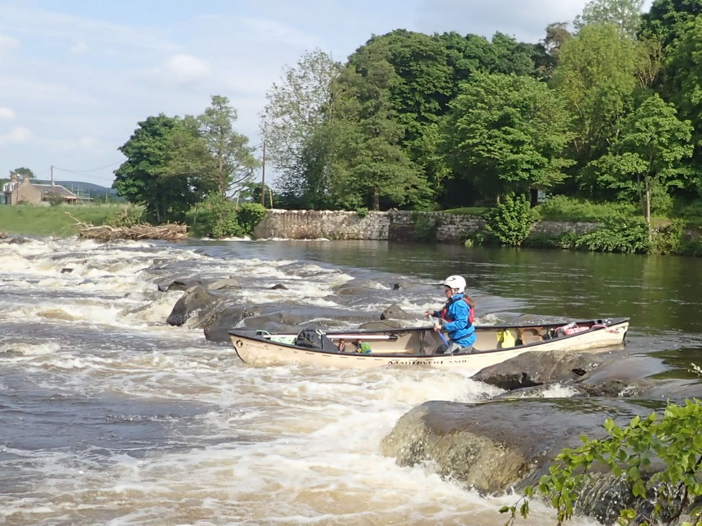
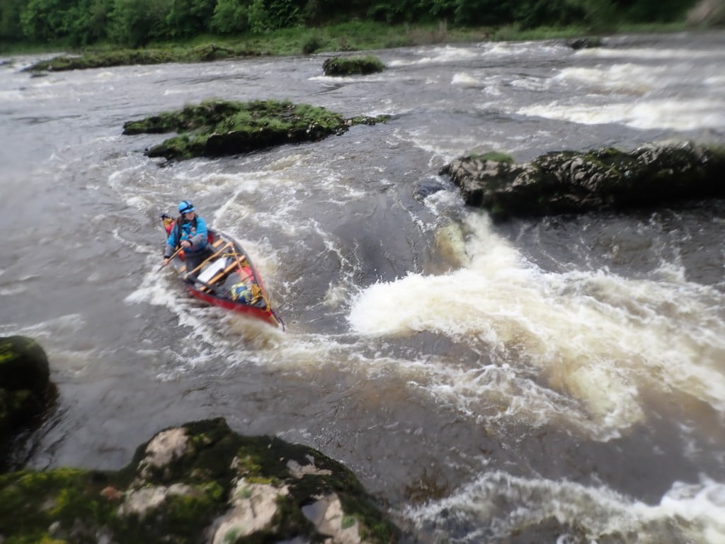
Before long we happened across the first Makerstoun Rapid. This was relatively easy at these levels with passage down the middle between numerous islands and rocky outcrops. Soon after we arrived at the Lower Makerstoun Rapid. There was the fire brigade swift water team just packing up after a training session on the river left. I could see the route down through on river right so headed off. We should have stopped and scouted the right-hand bank but it looked ok. This is a tricky grade 2 with narrow chutes and a sharp right turn at the bottom (grade 3). Martin and I managed to paddle down through and were just getting in position to take photos when Nikki tried a more skilful manoeuvre but the bow of her boat had other ideas, with the boat pinned at the front water started filling over the stern, it was all downhill from there.
On seeing this, the rest of the group decided to take the easier line down on river left. We never did find the river shoe which was eaten by the mighty Tweed.
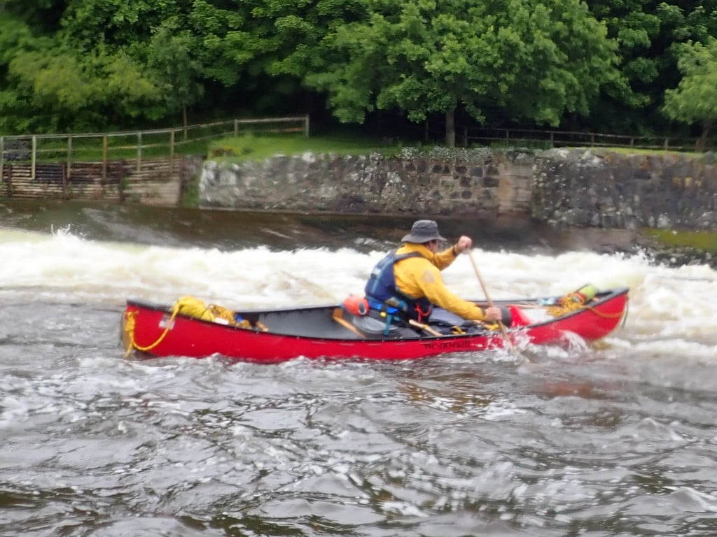
We stopped for elevenses and a warm drink a few kilometres down on a stone beach on the river right. Once refreshed and warm we paddled down to Kelso and its weir. There was too much water to take the concrete chute as in previous years so we opted to paddle on the river right down a large slope.

We paddled down through the town passing three local kayakers. There was no sign of the small weir below the bridge as the level must have been too high. After a few km`s we came across Banff Mill Weir. This was a large weir on river right of an island in the middle of the river but a series of 4 smaller weirs on the left of the island. Martin explored the right-hand side of the island, while we all made the most of 4 steps and small waves on each. We mopped out at the bottom before moving on.
We paddled down to Coldstream passing over 3 weirs on the way, Carham Cauld, Cauld near Lees and the one just below Coldstream bridge. After some discussion, we shot this on the river’s left, although the deeper water is on the river’s right. One small rapid (natural weir) around the corner and it was now mainly flat water down to the sea.
The weather was looking poor with dark clouds and light rain. We explored a few stopping places but nothing looked ideal. We then spotted a couple of fishing boats, one of which had overturned due to the high water levels. It was still moored up but its oars were floating in the eddy. These were swiftly rescued by Nikki and Keith went to explore the fisherman’s hut. The stone building was locked but it had a table and a small patch of grass beside it, ideal for 4 tents. They do not fish the river Tweed on a Sunday and we would be away early the next day.
It was now raining heavily and put up a tarp using a couple of special poles brought solely for this use (they could surely have no other use when the river was so high). Evening meals were prepared, clothes changed and gear sorted for the night.
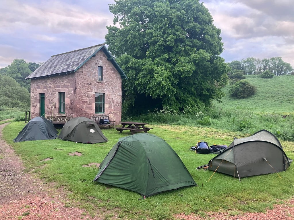
The fisherman’s cottage at Red Rocks proved an ideal night`s camp.
Day 3 (Sunday) 27th May – Red Rocks (Near Milne) to Berwick-upon-Tweed
We were up early in the morning having breakfast when a dog walker came along the track. We chatted a little before we finished up and packed everything away. We headed off downriver past a previous campsite on the outside of a large bend at Northam. There is a bridge followed by an island below Northam. All along the river we had been chased or led by what seemed to be the same three swans. These finally left us here to fly back upstream.

Union Bridge is very picturesque and Mike put us right on the history here. He even went into teacher mode for some of it. The river was clearly tidal at this point and we made swift time down to Paxton House where we landed at a small outdoor centre with covered seats. It was time for elevenses again!
Before long, we paddled under the A1 Road Bridge and then saw the the Royal Border Railway Bridge followed by the Berwick town bridges. We had left our cars near the Lifeboat station and this proved a good place to get out, even at low time. We avoided the very slippery seaweed-infested slipway and walked the canoes up the beach to the parking area at the top.

The usual cafe was crowded by the Berwick Bridge so we walked across to find an even better cafe on the opposite side of the harbour. The river Tweed makes an excellent bankholiday three-day trip in opens and is highly recommended.
Paddlers Martin, Nikki, Mike, Ruth, Ian and Keith


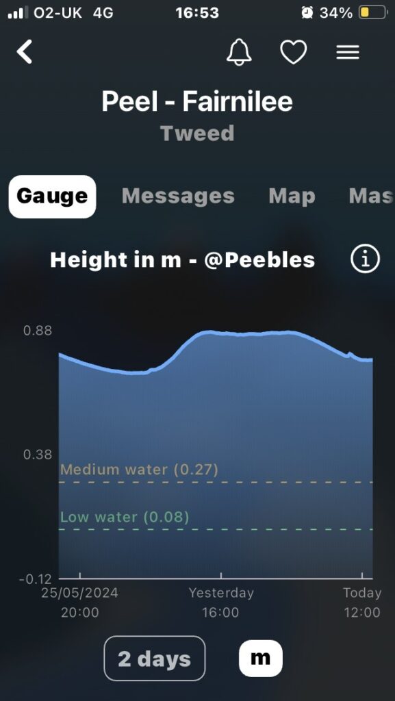
That looks excellent and more water than when we went in mid April. What level was it on the guage ? Well done.
Hi Neil,
I have added a screen shot of one of the gauges. It was at 0.88m at Peebles but had been higher during the week. Would be great to receive a short article on your trip with a picture or two. LCC